
Brick-Making Industry in Bangladesh
The brick-making industry in Bangladesh has thrived due to high demand for affordable construction materials. However, brickfields that use traditional, centuries-old technologies, mostly located on the outskirts of larger cities and towns, release dust, ash, black smoke, and other pollutants into the atmosphere. As a result, these emissions negatively affect air quality and may contribute to global climate change.
Data Analysis
This study used remotely sensed Landsat imagery to identify brickfield locations and track their areal expansion between 1990 and 2015 in Dhaka. Researchers also applied spatial statistical methods, including quadrat analysis and Ripley’s K-function, to examine the spatial variation of brickfield locations. Additionally, they calculated nearest-neighbor distances to six major geographical features—urban areas, rural settlements, wetlands, rivers, highways, and local roads—to assess environmental threats from nearby polluting brickfields.
The results show significant expansion of brickfields in both number and clusters between 1990 and 2015. Brickfields increased from 247 to 917, representing a 271% growth rate across the Dhaka urban center. Moreover, 78% of brickfields are located on major riverbanks, and 40% are in ecologically sensitive wetlands around Dhaka. Furthermore, the average distance from brickfields to the nearest urban area decreased from 1,500 m to 500 m during this period.
Overall, this research highlights growing threats to the environment, human health, and Dhaka’s urban sustainability due to the expansion of brickfields in peripheral areas. Therefore, the findings can support data-driven decision-making by government officials and city planners to improve brick production technologies and reduce environmental impacts.
Tracking Brickfield Locations
Most brickfields are rectangular, sometimes with rounded corners, and feature smokestacks 6–10 m tall. In particular, the study region predominantly uses Bull’s Trench or fixed-chimney kilns. These kilns have brick walls on the bottom, sides, and top, with an open top. Bull’s Trench operations are low-tech, inexpensive to build, and often located in the lowlands of Dhaka’s peri-urban zones. Typically, they operate from November to May, during the dry season.
Soft, muddy bricks are continuously fired into hard bricks within the same yard and kiln. Bull’s Trench technology dominates the region and is common throughout Bangladesh. In addition, high-resolution satellite images, including true-color and false-color composite multispectral images, clearly show brickfields and their operational areas, including shape, structure, and other characteristics.
Researchers used Landsat imagery from 1990, 1995, 2005, and 2015 to digitize potential brickfield sites. They utilized Google Earth’s time-lapse and high-resolution imagery. Although high-resolution images were unavailable for 1990, researchers used Landsat images as a proxy to track brickfield clusters. By comparing time-lapse and high-resolution imagery, they could map and trace each brickfield’s approximate location. Finally, they identified all brickfield sites on 2015 imagery and recorded their extent and centroids.
Brickfield locations in 2015 in greater Dhaka
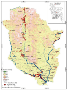
Figure 1. Elevation and brickfield locations in 2015 in greater Dhaka. An inset map in the top right corner shows the study area of greater Dhaka’s geographical position (red square box) in Bangladesh.
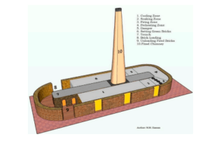
Figure 2. Schematic diagram of traditional fixed-chimney Bull trench clay-made brick burning kilns.
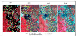
Figure 3. The shape and structure of traditional brickfields are visible in high-resolution Google Earth imagery (top) and digitized brickfield locations overlaid on false color composite Landsat imagery across the study period (bottom).
For more details, please Contact Us.
or, WhatsApp Us: +880 1713222363